|
|
|
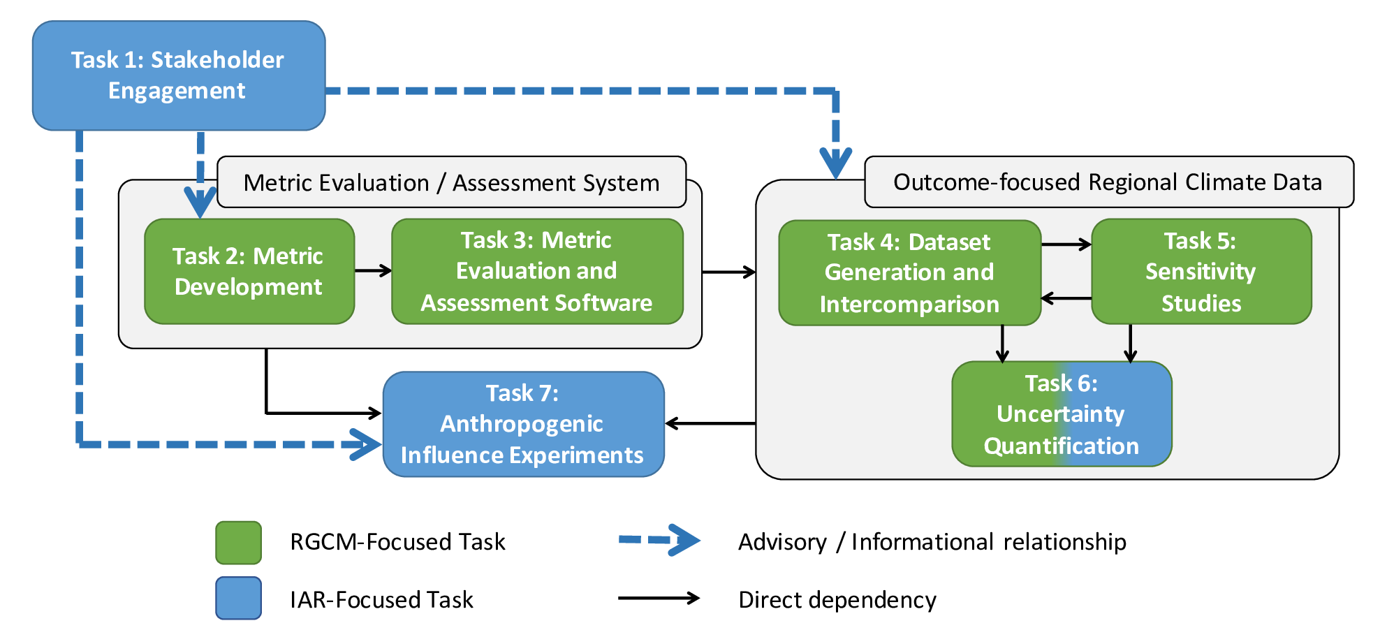
All work associated with this project has been categorized into seven interwoven tasks. To accomplish its objectives, Hyperion incorporates (1) continuous outreach and engagement to ensure a focus on stakeholder needs, (2) development and accumulation of metrics associated with processes, features, and outcomes, (3) a software suite capable of directly evaluating the quality of regional climate and hydrological datasets, (4) production of high-quality regional climate and hydrological data that can be used for broader applications, including future projections, (5) model optimization and sensitivity experiments so as to maximize their capability to credibly simulate the integrated hydroclimate system, (6) an assessment of uncertainty linking process-based representations, model coupling, and resolution to stakeholder-relevant outcomes and (7) sensitivity experiments to characterize the magnitude and scale of irrigation influences on the climate system. These tasks are addressed in detail below.
|
|
|
|
This task encompasses all efforts associated with stakeholder outreach. Engagement with the stakeholder community (particularly water managers) is a key feature of the project plan, and includes an ongoing dialogue addressing the development of decision-relevant evaluation metrics, case studies, scenarios, and approaches to uncertainty quantification. A number of recent workshops and reports have identified a need for greater dialogue among climate practitioner and academics so as to support the "co-production" of knowledge that simultaneously addresses the information needs of decision-makers while advancing scientific understanding. These include a recent RGCM-funded workshop on "Impact Relevance and Usability of High Resolution Climate Modeling and Datasets" co-chaired by Co-I Jones and attended by Co-I's Collins, Hall, and O'Brien. In this task, we respond to those calls by making stakeholder engagement and feedback a cornerstone of the overall project design and execution.
|
|
|
|
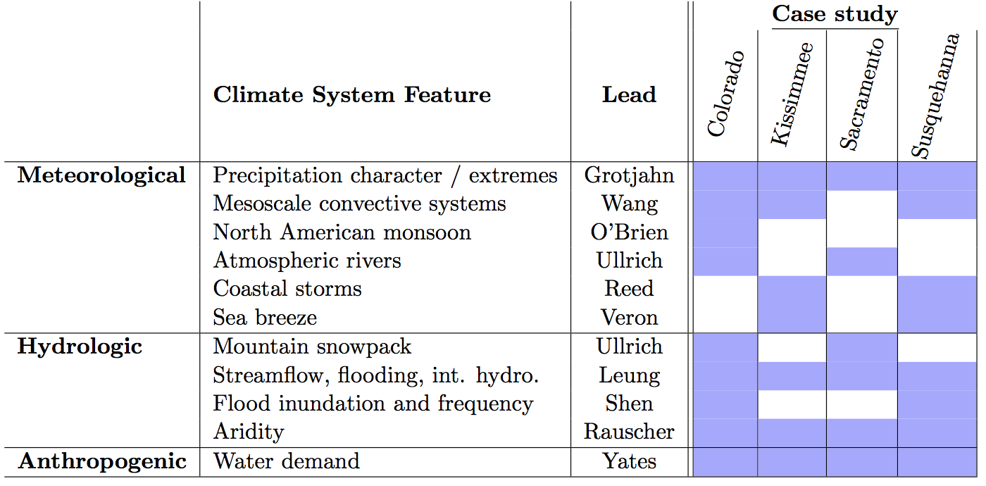
This task focuses on the development of high-quality regional climate model metrics and metric assessment/validation techniques. Feature-oriented metrics will be developed by examining meteorological and hydrologic phenomena and quantifying key characteristics, particularly those that have a direct human impact. Conditioning of metrics to certain meteorological conditions will be emphasized during the development process (for example, streamflow during dry conditions vs. wet conditions), so as to provide a means of characterizing functional responses. These metrics will then be refined to produce outcome-oriented metrics that are relevant for stakeholders.
|
|
|
|
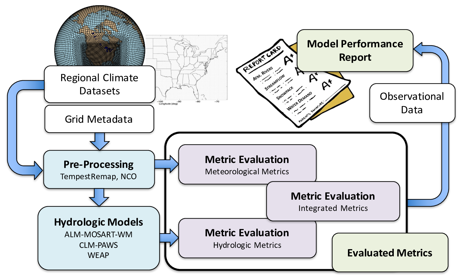
The software task is a cornerstone element of the proposal and focuses on the development of a robust software suite that will allow modeling groups to take a regional climate model dataset and (a) systematically evaluate feature-relevant metrics that emerge from Task 2 and (b) assess the quality of the dataset in terms of correspondence between evaluated metrics and observations.
|
|
|
|
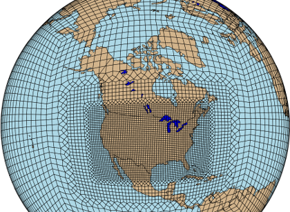
In this task, several regional refinement techniques will be used to produce data corresponding to a 30-year baseline period (1986-2015) and a 40-year near-future period (2016-2055). Data will be produced for the entire CONUS with a base resolution 28~km (0.25°) using a high-resolution domain. Much higher resolution data (roughly 1-10 km) will also be produced for the four case study regions. Simulations will use AMIP protocols, which impose fixed sea-surface temperatures and greenhouse gas concentrations. The requirements for the high-resolution regional climate data will be determined in collaboration with stakeholder groups. Protocols for dataset generation will be designed to characterize model fidelity in the baseline period, support sensitivity analysis, and produce a rich archive of future regional projections to better measure uncertainty in the future decision-relevant outcomes identified in Task 1.
|
|
|
|
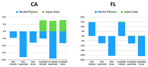
This task aims to understand how resolution, parameterizations and options for regional climate data can be optimized to produce hydrological and climatological features of the highest quality (assessed in accordance with the software assessment system of Task 3), and how these datasets can be produced to maximize utility for stakeholders. The methods for generating regional climate information used in this project -- dynamical downscaling, variable resolution modeling, and statistical downscaling -- feature a variety of configuration choices (domain, resolution, parameterizations, etc.) that are directly responsible for uncertainties in the regional climate data. There is a long history of work in the RCM literature, and, more recently, regarding VR modeling, demonstrating that regional climate statistics are sensitive to a variety of configuration choices, such as: Resolution, domain size/extent, parameterization choice, and poorly constrained parameters.
|
|
|
|
This task identifies the upstream process-level uncertainties, model biases, and scaling relationships that contribute to uncertainty in decision-relevant hydrologic outcomes. The metrics developed for this project (Task 2) cover a wide range of processes and outcomes associated with the integrated hydrologic cycle of the US, including several decision-relevant metrics deemed critical to resolving the management challenges of the stakeholder community (Task 1). The systematic and comprehensive nature of this suite of metrics, combined with a multi-model, multi-resolution, multi-parameter ensemble of generated hydroclimatic datasets (Tasks 4-5), presents an unprecedented opportunity to link uncertainty in decision-relevant outcomes to uncertainty in specific model process representations and downscaling methods, and to factors such as model configuration, coupling schemes, resolution, domain size, etc.
|
|
|
|
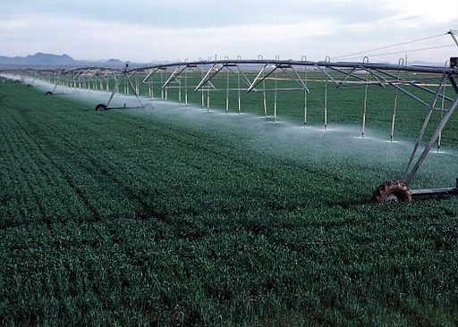
In this task, we develop sensitivity experiments that exercise the dataset generation and model evaluation framework to quantify the influence that humans have on regional hydroclimate. Of all potential anthropogenic actors on regional climate, we focus on irrigation, as it represents by far the largest deliberate anthropogenic perturbation to the natural hydrological cycle. In the US, irrigation accounts for 80% of consumptive water use. According to the the most recent report of the Major Land Uses series from the US Department of Agriculture, of the US's total 2.3 billion acres, 408 million (18%) is cropland, and about 57 million acres (17%) of this cropland is irrigated, giving it the potential to influence the regional water cycle at the scale of the CONUS.
|
|
|