
|
|
|
|
Climate Model Development and Assessment
Climate Data
- Extreme weather
- Detection and characterization algorithms
- Large-scale drivers of regional climate
- Climate data mining
|
|

The production of actionable climate science relies on effective communication of regional climate information and its associated uncertainties across sectors. To be of value beyond academic circles, climate data must be sufficiently credible (i.e., physically grounded), understandable (communicated in the vocabulary of the decision-makers), and useful for the particular decisions that need to be made. Comprehensive assessment of both dynamical and statistical climate models adds substantial value to their outputs, particularly when the evaluation criteria are the product of a two-way dialogue between scientists and end-users. Substantial progress has now been made on developing comprehensive frameworks for climate data assessment that incorporate process-oriented, feature-specific, and use-inspired metrics. These efforts have been particularly advanced over the continental U.S. (CONUS) under both the Department of Energy Hyperion and FACETS projects. Our proposal for the joint continuation of these efforts will extend these past projects so as to further (1) advance our understanding of processes at the climate-water-energy-land-decision interface, and (2) fundamentally improve our ability to perform credible climate modeling of particular regions.
For more information, check out the HyperFACETS website.
|
|
|
The next century will see unprecedented changes to the climate system which will have significant repercussions on global human activity and international policy. The IPCC special report on extreme weather reports with confidence that the next century will see substantial warming, with a corresponding increase in regional temperature extremes and drought conditions, increases in the frequency of heavy precipitation events in wet areas, and increases in tropical cyclone wind speeds. These trends are of a broad global nature and do not necessarily reflect the influence of the changing global climate on regional scales, which are absolutely key for planning on the local, state and federal level. For this reason, an understanding of changing regional climate and its associated uncertainty is an unmet challenge that must be addressed in the coming decade.
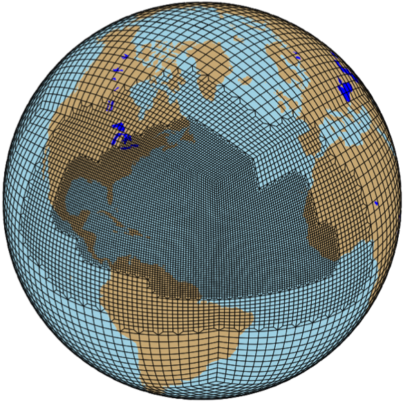
Variable-resolution climate modeling is a cutting-edge technology, with efforts only recently directed towards support for multiple mesh scales within a single framework. It is also a timely endeavor, since demands for fine-scale resolution of atmospheric features have taxed the limits of our most powerful computing systems. However, even as variable-resolution software systems have moved forward, there has been a discernible lag in our understanding of exactly how these systems improve the representation of regional-scale behavior. Intuitive regional metrics which include both expectation and variability of seasonal precipitation and surface temperature, as well as the count and variability of extreme weather events, can be readily estimated by variable-resolution Earth modeling systems. These metrics are of considerable importance in informing regional-scale policy and implementation for agricultural planning, forest fire prevention, urban development, and many other relevant fields. A better understanding of the uncertainty present in the estimates of these metrics is significant for both improving our scientific understanding of the Earth system and lending credibility to the conclusions drawn from these models.
|
|
|
Climate change is anticipated to cause both prolonged and more intense heat waves. Therefore, it is in the public interest to know what sorts of changes in frequency and duration of these events can be anticipated in the upcoming decades. Atmospheric blocks, stationary high-pressure systems that cause deviations in the jet stream, are a major component in such events. A detection algorithm for tracking atmospheric blocks is being developed and tested on global reanalysis data; after the results have been verified, the algorithm will be applied to data that has been forced based upon a number of potential climate scenarios. Other questions of interest include the dynamics that precede and succeed the formation of these blocks.
|
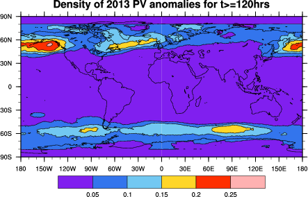
Figure: Atmospheric block density (block duration at least 120 hours) from ERA-Interim data.
|
|
|
|
Extratropical cyclones (ETCs) are extreme weather events associated with transient low-pressure systems occurring in the mid-latitudes, known for producing damaging levels of wind, precipitation, low temperatures, and flooding. Under future projections of climate change, ETCs are hypothesized to decrease in number but increase in intensity. ETC statistics from the Community Earth System Model (CESM) are assessed using an automated detection and characterization-based approach. This method is applied to multi-year global simulations with static climatological forcing using experiments developed by the U.S. Climate Variability and Predictability (CLIVAR) project and simulated using the global Community Atmosphere Model (CAM) version 5.1 at two resolutions (approximately 100 km and 25 km at the mid-latitudes). This study investigates the robustness and sensitivity of our detection algorithm using climate variability experiments, which allow for isolation of changes to ETC features with different forcing mechanisms such as elevated SSTs and higher atmospheric carbon dioxide concentrations. Since ETCs have a large socioeconomic impact and are expected to cause $2.4 billion damage globally in the next century, better understanding of how these storms have altered with climate change is crucial to plan and minimize disaster impacts.
|
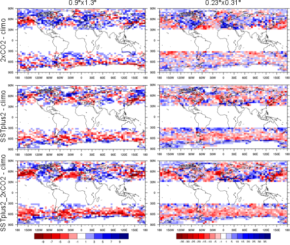
Figure: Difference in ETC counts between experiments and climo, using the new results.
|
|
|
|
Snowpack is crucial for the western USA, providing around 75% of the total fresh water supply and buffering against seasonal aridity impacts on agricultural, ecosystem, and urban water demands. The resilience of the California water system is largely dependent on natural stores provided by snowpack. This resilience has shown vulnerabilities due to anthropogenic global climate change with future trends of western USA SWE declining by 40-70%, snowfall decreasing by 25-40%, and more winter storms tending towards rain rather than snow. The volatility of Sierran snowpack is largely driven by orographically forced weather fronts and large-scale teleconnections, such as atmospheric river events, necessitating the use of high-resolution global scale modeling tools. Variable-resolution global climate modeling (VRGCM) is a promising next-generation tool to analyze California’s past and future hydroclimatic trends. VRGCMs serve as a bridge between regional and global models by providing added resolution in areas of interest, eliminating lateral boundary forcings (and resultant model biases), and allowing for more dynamically inclusive large-scale climate teleconnection signals, all while providing serious computational efficiency upgrades. My current research focuses on validating these next-generation models with the goal of using them to project future climate change scenario impacts on several of California’s key hydroclimate metrics (e.g., snowpack, snowfall, and precipitation) to inform water managers and policy makers and help them prepare for climate change impacts facing the state.
|
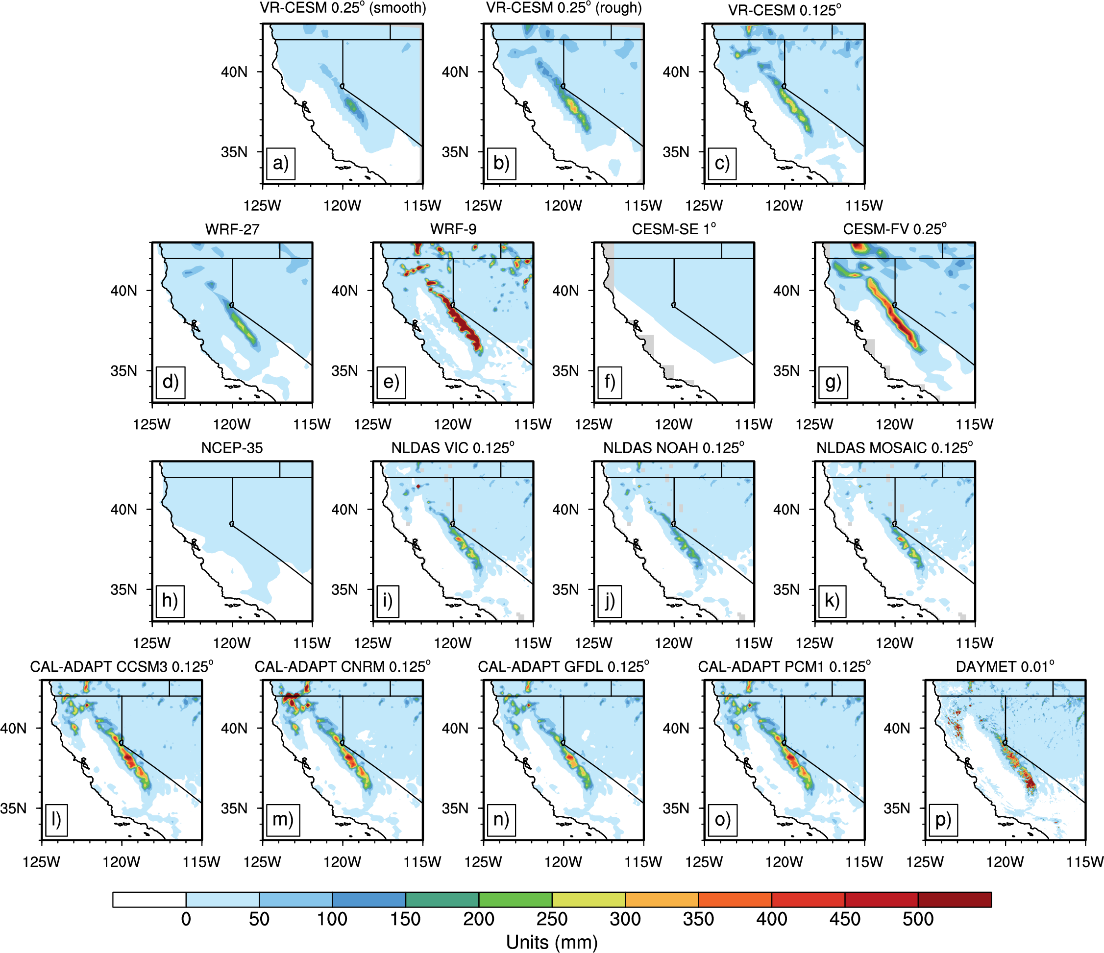
Figure: Winter season (DJF) average snow water equivalent over the Sierra Nevada mountain range, as simulated by a variety of models.
|
|
|
|
Regional climate modeling using multi-scale and regionally-refined climate models is an emerging field. Work is ongoing on the assessment of the variable-resolution option within the Community Earth System Model (CESM) for long-term (26 years) regional climate simulation over California, in contrast with one of the traditional regional climate models, the Weather Research and Forecasting (WRF). The results show that variable-resolution CESM is competitive in representing regional climatology on both annual and seasonal time scales. This assessment will add value to the use of VRGCMs for projecting climate change over the coming century and improve our understanding of both past and future regional climate related to fine-scale processes.
|
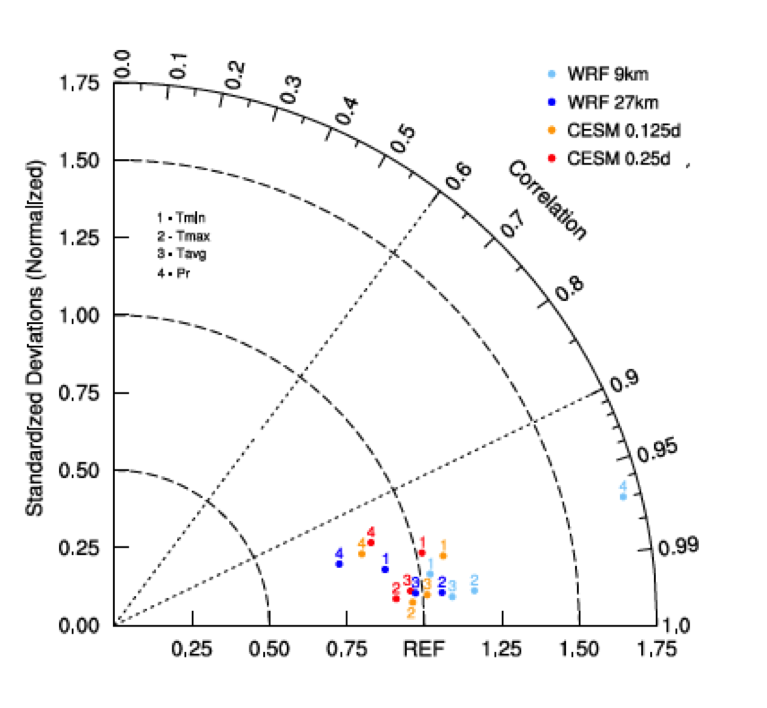
Figure: Taylor diagram of temperature and precipitation related variables associated with climate over California.
|
|
|
|
Work is ongoing on the development of high-order vertical discretizations for climate and weather simulation. More accurate and robust methods are needed for the non-hydrostatic equations applied to high-resolution models. In particular, we focus on the dynamic influence of steep topography on atmospheric flows. To meet these needs, we employ finite element methods known for their flexibility and suitability for massively parallel computing. A variety of physical and mathematical considerations arise when simulating the atmosphere in the non-hydrostatic regime. The goal of this research is to find and implement methods that reproduce vertical motion in the atmosphere at high resolution and will ultimately lead to improved precipitation forecasting at high resolutions with an emphasis on mountainous regions.
|
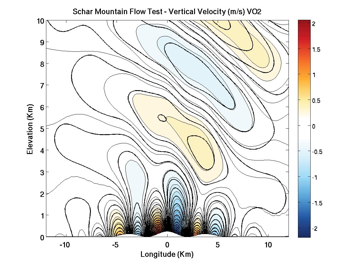
Figure: Vertical velocity in the presence of a Schar-type mountain range.
|
|
|
|
The large-scale drivers of many important regional-scale climatological features in California are still not well-understood. This work focuses on meso-scale atmospheric dynamics, and implications of regional climate change. Current work focuses on sea breeze and coastal fog detection/attribution, investigating possible interactions and future changes under the climate change. Methods currently used including analyzing observation and reanalysis datasets, classifying indicators and synoptic-scale predictors, as well as running model simulations with WRF and CESM.
|
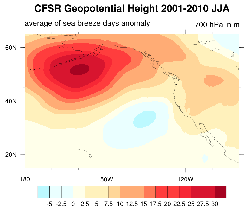
Figure: Geopotential height anomalies on days where CFSR reanalysis indicates the occurrence of a central valley sea breeze event.
|
|
|
|
Computing power has increased exponentially over the past decade, stimulating a significant burst of new research focused on developing software that can take advantage of the rapidly advancing hardware. In particular, it has become increasingly important to design atmospheric models which are capable of scaling on systems with tens to hundreds of thousands of processors. Hence, significant effort has been directed to the study and application of modern numerical techniques to simulating the atmosphere.
The most popular modern schemes include discontinuous Galerkin, spectral element and finite-volume methods. These methods all have well known advantages and disadvantages, however the comparative performance and accuracy of these methods for smooth, well-resolved problems is largely missing from the literature. Although the modeling community has pressed forward with the usage of these methods in dynamical models, there remains a significant number of unanswered mathematical problems that remain to be answered. Without a rigorous mathematical foundation, spurious errors are bound to arise in geophysical models which may pollute the solution in unexpected ways.
Our work on numerical analysis aims to close these gaps in the understanding of these methods, and establish a solid mathematical foundation for the development of atmospheric dynamical cores.
|
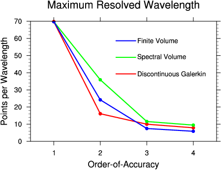
Figure: Shortest wave mode which is resolved to at most 0.5 percent error in the advective dispersion relation of the numerical method. Wave modes below this threshold are considered poorly resolved by the numerical method.
|
|
|